Major upgrades are being carried out to transform the Coodanup Foreshore into a more vibrant and better-connected space for Mandurah locals and visitors.
Guided by the City of Mandurah’s Coodanup Foreshore Master Plan, the significant upgrades have been split into five stages with a key focus on improving amenities and protecting the area’s natural environment.
What’s happening now?
Stage 5: Community consultation
Now is the time to have your say on the final stage of the Coodanup Foreshore upgrades, with consultation for Stage 5 underway.
Stage 5 represents the final component of the project and focuses on enhancing the areaContinue reading
Major upgrades are being carried out to transform the Coodanup Foreshore into a more vibrant and better-connected space for Mandurah locals and visitors.
Guided by the City of Mandurah’s Coodanup Foreshore Master Plan, the significant upgrades have been split into five stages with a key focus on improving amenities and protecting the area’s natural environment.
What’s happening now?
Stage 5: Community consultation
Now is the time to have your say on the final stage of the Coodanup Foreshore upgrades, with consultation for Stage 5 underway.
Stage 5 represents the final component of the project and focuses on enhancing the area adjacent to the Nairns Bird Hide and surrounding wetlands.
At this early stage, we are seeking community feedback to help shape the concept design. Input received will directly inform the development of a draft concept plan, which will then be shared back with the community later this year.
The proposed scope includes:
- Improved car park layout
- New and upgraded paths, connecting into the new stage 4 paths.
- Installation of park furniture and public amenities
- Extensive planting and revegetation to enhance canopy cover and provide habitats for wildlife
Provide your feedback through the survey here.
Stage 4: Construction
Construction works for Stage 4 are now underway. This includes extending the current path further east along John Street, which will improve accessibility and allow locals and visitors to enjoy more of the foreshore.
Project History
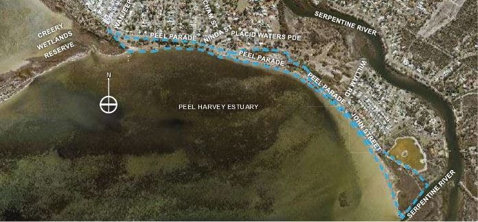
A Coodanup Foreshore Master Plan was developed to provide strategic guidance for the area’s future. The foreshore is located on Peel Parade between Wanjeep Street and the end of John Street to the Serpentine River, Coodanup, on the northern foreshore of the Peel Harvey Estuary.
The Peel Harvey Estuary sits inside the boodjar (country) of the Bindjareb (Pinjarup) Noongar people. The Bindjareb people refer to the Peel Harvey Estuary as Djilba. This is the ancient name used for thousands of years. Both names are used on the Masterplan.
Why do we need a new plan and development?
A framework was needed to update the area, manage this valuable community space, and address future opportunities form a more vibrant space while respecting the local environment.
The Coodanup Foreshore is a large and popular reserve which spans approximately 2.6 kilometres and a total of 15.9 hectares. The foreshore forms a part of the Peel-Yalgorup system, which is listed under the Ramsar Convention's List of Wetlands of International Importance. The City recognises the foreshore reserve as a valued community asset with well-established facilities, trees and foreshore habitat and activities.
However, the previous standard of the foreshore falls short of the standard expected for key reserves that have a Regional Reserve classification. The opportunity to improve the reserve has been recognised and the City has worked to address this by developing a masterplan for the full project site.
Input from the local community is greatly valued and has been used to inform the design process, thank you to all that have taken part. Learn more about the process and community involvement by visiting the frequently asked questions (FAQs) and consultation report.
Where can I view the Coodanup Foreshore Master Plan?
You can see the full Coodanup Foreshore Master Plan here. It is also listed in the documents section of this webpage.
Need more info?
Call our Landscape Services team on (08) 9550 3777 or email landscape.services@mandurah.wa.gov.au


 General