We use cookies to ensure our site functions properly and to store limited information about your usage. You may give or withdraw consent at any time. To find out more, read our privacy policy and cookie policy.
Manage Cookies
A cookie is information stored on your computer by a website you visit. Cookies often store your settings for a website, such as your preferred language or location. This allows the site to present you with information customized to fit your needs. As per the GDPR law, companies need to get your explicit approval to collect your data. Some of these cookies are ‘strictly necessary’ to provide the basic functions of the website and can not be turned off, while others if present, have the option of being turned off. Learn more about our Privacy and Cookie policies. These can be managed also from our cookie policy page.
Strictly necessary cookies(always on):
Necessary for enabling core functionality. The website cannot function properly without these cookies. This cannot be turned off. e.g. Sign in, Language
Analytics cookies:
Analytical cookies help us to analyse user behaviour, mainly to see if the users are able to find and act on things that they are looking for. They allow us to recognise and count the number of visitors and to see how visitors move around our website when they are using it. Tools used: Google Analytics
Share Halls Head Parade - Coastal Shared Path on FacebookShare Halls Head Parade - Coastal Shared Path on X (formerly Twitter)Share Halls Head Parade - Coastal Shared Path on LinkedinEmail Halls Head Parade - Coastal Shared Path link
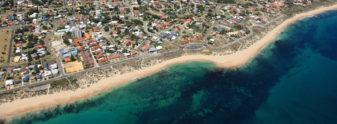
The Halls Head Shared Coastal Path has now compete, with an official opening coming soon.
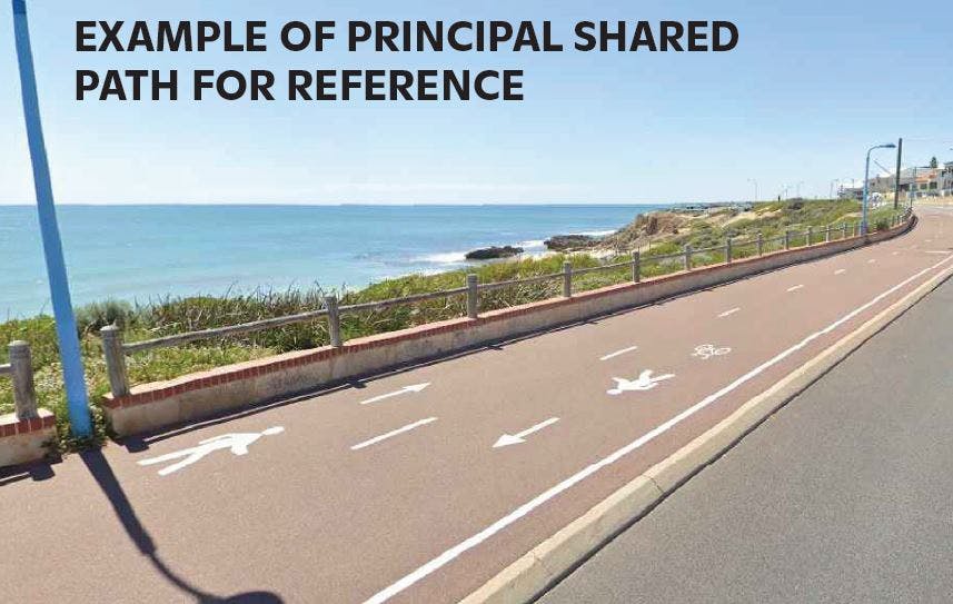
In collaboration with the Department of Transport, the City of Mandurah is implementing a high-quality coastal shared path between Janis St in the south and Sharland St (Doddi's Beach) to the north.
This design for this shared coastal path was created following community consultation in 2020, and further consultation with residents regarding local parking areas. See the previous consultation summary in the consultation report.
This consultation confirmed two key areas of focus for the path including:
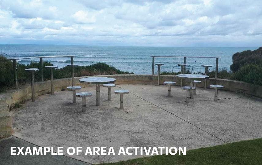
By connecting to existing paths along the coast, this project aims to improve safety for both cyclists and pedestrians by removing conflict areas with driveways and intersections experienced by path users on the existing concrete footpath on the developed side of the road. Improved amenities along the path also provide more activated spaces, encouraging our community to get out, get active and enjoy our beautiful coastal areas.
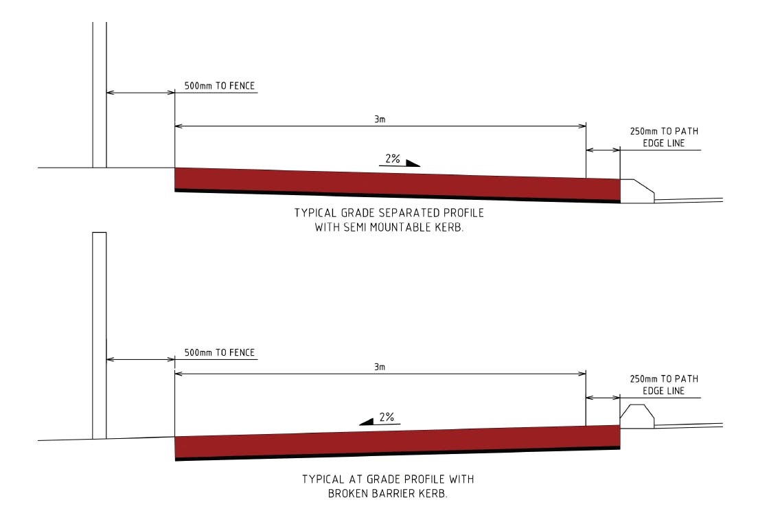
The sensitivity of the adjacent dunes was also considered in the design of the project and was a key area of interest expressed by our community in the initial consultation. To address this, areas of the path have been adjusted to move into the road and carparks in some areas, away the from dune. This also provides traffic management, addressing another key concern of local residents. Many areas of the path also travel through degraded or weedy areas which will be rehabilitated with native species once the pathway has been completed.
This path link has been identified as part of the City's big-picture plans to improve walkability and cyclability in Mandurah, particularly by providing a continuous connection along the island. See the Long-Term Cycle Network Plan.
The Halls Head Shared Coastal Path has now compete, with an official opening coming soon.
In collaboration with the Department of Transport, the City of Mandurah is implementing a high-quality coastal shared path between Janis St in the south and Sharland St (Doddi's Beach) to the north.
This design for this shared coastal path was created following community consultation in 2020, and further consultation with residents regarding local parking areas. See the previous consultation summary in the consultation report.
This consultation confirmed two key areas of focus for the path including:
By connecting to existing paths along the coast, this project aims to improve safety for both cyclists and pedestrians by removing conflict areas with driveways and intersections experienced by path users on the existing concrete footpath on the developed side of the road. Improved amenities along the path also provide more activated spaces, encouraging our community to get out, get active and enjoy our beautiful coastal areas.
The sensitivity of the adjacent dunes was also considered in the design of the project and was a key area of interest expressed by our community in the initial consultation. To address this, areas of the path have been adjusted to move into the road and carparks in some areas, away the from dune. This also provides traffic management, addressing another key concern of local residents. Many areas of the path also travel through degraded or weedy areas which will be rehabilitated with native species once the pathway has been completed.
This path link has been identified as part of the City's big-picture plans to improve walkability and cyclability in Mandurah, particularly by providing a continuous connection along the island. See the Long-Term Cycle Network Plan.
Share Open Discussion Forum on FacebookShare Open Discussion Forum on X (formerly Twitter)Share Open Discussion Forum on LinkedinEmail Open Discussion Forum link